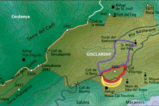
Gisclareny, his routes in capital letters
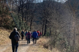
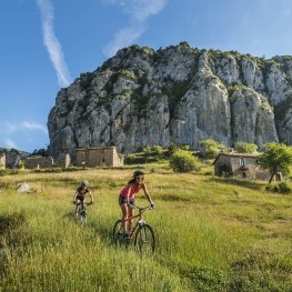
Gisclareny, a small town in the Berguedà region, is a natural jewel included in the Cadí Moixeró natural park. The municipality borders Bagà, Cerdanya, Saldes,Vallcebre and Guardiola de Berguedà and is home to unique landscapes that make it an extraordinary mountain corner. In order to enjoy its potential of forests, peaks and alpine meadows, we suggest a route that includes several itineraries, specifically we are talking about an itinerary for each letter that makes up Gisclareny. Therefore, we propose ten itineraries through the places of the municipality.
Below, we will give you a preview of each route so that you can choose the one that best suits your plans, or if you prefer, you can start with route G and continue with route I, until completing all the routes that make up GISCLARENY.
Route G: La Dou
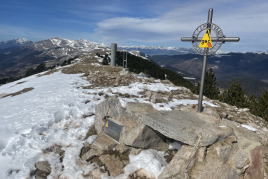
This route begins and ends at Coll de la Bena (1,450 m), the highest point of this route that we will do in approximately four and a half hours.
The itinerary allows us to contemplate the richness and diversity of the vegetation in the area, such as Scots pine, hazelnut and holly among other species, as well as a landscape of great beauty, mainly in the Prados de Escriba area, from where we will be able to see the Sierras del Cadí and Ensija and Pedraforca. The route takes us to the source of the Bastareny river and to the Bauma del Obispo, a formerly inhabited cave. The first hour and a half of walking brings us closer to the Dou (945 m), the lowest point of the route. Sant Martí del Puig, the meadows of the Escriba, the Gisclareny fountain are the areas through which we will pass along this excursion until we reach Coll de la Bena again.
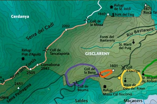
Route I: La Voltrera
The Coll de la Bena is the starting and finishing point of this route of just over two hours and which has a 200-meter drop in altitude from the highest point (1,520 m) to the lowest, the Gisclareny spring (1,300 m). ).
It is an itinerary with magnificent panoramic views of the Bastareny Valley and the Sierra de Moixeró. Just 30 minutes after starting the walk we will cross a red pine forest where, if we are quiet, we may be able to observe some chamois or feel the chime of the peak. From the Coll de la Bena, the path takes us through the Baga Voltrera, continues below the Roca d'en Bosc, passes the Gisclareny spring and finally reaches the Coll de la Bena.
Route S: El Pinar
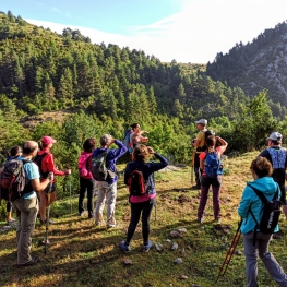
This route of only an hour and a half of walking, has almost no unevenness, which also makes it very suitable for all those who want to start hiking in the mountains.
It starts and ends in the Gisclareny Town Hall square and first goes up to Cal Martinet and Coll de la Sierra and then goes down to Coll de Jovell and finally reaches the town hall square. Along the route we will mainly find very attractive landscapes, from the Sierra de Ensija to the views of Saldes, Maçaners and Pedraforca.
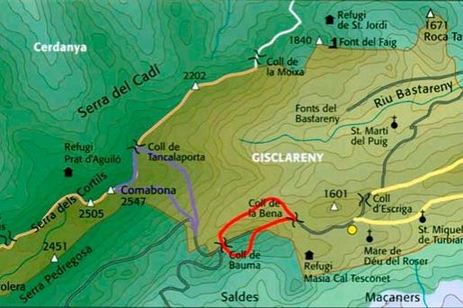
Route C: Comabona
This itinerary begins at the curve that comes after Coll de Bauma, where you must take a forest track to the right that is closed with a barrier. After about 100 meters there is a path to the left that goes up through the forest (Clot de la Pleta de la Olla).
Next we will arrive at Grau, a place with little vegetation, where we will have an incredible view of the north face of Pedraforca, the Sierra de Ensija, the Valley of the Saldes river, Gisclareny, the Bastareny valley. We continue to the left, crossing the meadow above the remains of a shepherd's hut. We zigzag up and we come out to Cap del Grauet. This place is a viewpoint over the Monnell Valley, the Sierra de la Moixa, the Moixeró, the Pedró dels Quatre Batlles (Tosa) and the Puigllançada. We will continue to the left and diagonally, and we will arrive at the Pleta de la Guilla; if we try to go quietly we will have the chance to see a herd of chamois grazing in this area. We will continue going up and we will pass to the left of the Monte de los Terreros, we will come out to the Coll del Tancalaporta and we will follow the Comabona on the eastern side to the top. The return will be made through the Clot de Comabona, and we will end up on the forest track near where we had started the itinerary.
Route L: Coll de Bauma
The beginning of this itinerary is Coll de la Bena. From there we will take the middle track in the direction of the torrent. Before arriving we will find, on the left hand side of the path, two holes that are old ovens that had been used to make tiles.
Then we will take the path to the left that goes up through the forest, which later crosses a torrent of clear waters rich in fauna and that goes up to the right. When we almost arrive at Coll de Bauma we will find the Coll de Bauma fountain and some stoves prepared to enjoy a day of recreation. We will also see a raft protected with a fence: it is a water tank to be used in case of fire. We will continue going up a little more and we will arrive at the pass. We cross the forest track and we will turn left into a beautiful forest, where we can see two species of pine: red pine and black pine. We will go up until we reach a Coll where we will once again turn left along this stretch. If we look to the right of our route we will see the work carried out by the Picot de Gayet reflected in a pine tree. We will glide until we find the forest track that we had previously crossed the Coll de Bauma and we will not leave it until we reach the Coll de la Bena, where we had started the excursion.
Route A: Turbians
We will leave the junction of the Gisclareny road with San Miguel de Turbians and along the forest track we will go to San Miguel. At the height of the San Miguel sign, we leave the track and come out onto a meadow with views of Pedraforca and Comabona.
To the right of this plain is the church of San Miguel, which can be visited. At this point, the Coll de San Miguel, the path turns to the left and passes through an area of holm and oak trees. Further on, the path opens up and we pass through a terrace where there is a small colony of poplars; soon we come out to a track, we continue to the right; a little further on we take a detour to the left in the direction of Cal Ralé.
Below the house and in an easterly direction, the path goes up through a wooded area. We arrive at a point where the path ends at a track; We follow it for a bit and then take a path that turns left and passes by a fountain: the Cal Pere Vilella fountain. The path goes up through the forest until it comes out at Coll de Turbians.
From the pass we have to go in the direction of Roca Tiraval. Five minutes from the pass we will leave this path and take a path to the left that goes up through the forest until we reach the Coll de Culledassa.
From here the path goes along the ridge; if we get closer to the crest, we will see an impressive view of the Bastareny Valley. We arrive at Cap del Cau. Here we turn a little to the right and pass next to a raft; We continue along the crest, we pass through the Cau plain; from this point the path goes down. We will pass through the rubble of a house (la Portella). Shortly after we will arrive at Coll del Escriba, and from there to the starting point.
Route R: La Encina
We leave the San Miguel de Turbians crossroads, pass through Grado del Cura and, before reaching the church, turn left. We go down to the Coll del Cabo de las Barreras; to the right we have the Pedraforca and the church of San Miguel de Turbians.
We go down to the track that takes us to the neighborhood of Vilella, passing between the farmhouses of El Paraíso and Cal Ponet. We continue in an easterly direction, we find a waterfall, the Fuente de Abajo, and we continue until the track ends, in the Dehesa del Toros. Here we take a path inside the forest again. After a few meters, the path forks; we take the one on the left and go up to Cap del Grapis. Here the path goes down to the shade of Costa Fría. We find a crossroads and we take the one on the right, which remains flat; We pass through a place where you have to be careful, because on the right there is a big cliff. We continue east, change slopes and see the Saldes and Vallcebre Valley, the Cal Noguera house and the Coma Oscura oak forest. We follow the back of the mountain and pass over Ca la Estevenó. We continue in the direction of Cal Noguera, where we can see a hundred-year-old holm oak very close to the house. From here the path begins to climb. We leave one very marked on the right and continue to the left and soon turn right. The path enters a Clot that, with a steep and zigzag slope, reaches an area of crops and the Roca de Cans farmhouse. We pass through the lower part of the house, enter the forest and come out to Coll de Turbians. Once we are at the pass, we follow the forest track until we reach the beginning of the route.
Route E: The Lakes
We left the Gisclareny spring. We continue along the road to Coll de Cal Jovell. We follow the track in a southerly direction and after ten minutes we arrive at the Mateu pass. We enter the pine forest until we reach an oak grove, the Alou. We continue along the track to Coll de Jou.
Here we take a path inside the forest, heading east. We arrive at the ruins of Cal Paxena, we come out into an open space and pass by other ruins of the House of the Lakes. We continue east, from where we see San Miguel de Turbians and the Vilella neighborhood; to the right we have the gorge of the pine trees. Shortly after, where the path turns to the left, we enter the shady area and change the view: Cal Ros is just ahead, the Balma cliffs to the right, Cal Cazador below and further to the right the Villalla neighborhood. We continue now inside the forest; to the right is the Cinglera del Grau and further to the right the Canalassa. We found a conglomerate of pumice stone. We cross to the right, below this stone, and arrive at a pass, the Passant del Grau. We turn left, next to a natural rock wall, until we come to the Grau Pass. Opposite we see the house of Cal Ros and the remains of the Castle of Fener. From here, the path goes up through a hub area where large rocks with bear's ears and butcher bushes are interspersed. Soon we will see a very large stone on our right, the Roc de Donzell. We continue going up and we arrive at the beginning of the itinerary.
Route N: La Solana
We leave Coll de la Bena and take the forest track in the middle towards the stream. We leave the track and take a path on the right. We pass by the weather station and continue towards the stream. We find an old hauling road, pass through the shade of Las Rentadora and cross the stream.
We continue the path, inside the forest, and cross another stream. We headed east. We leave the path on the right and continue up the path on the left. We came out onto a plain, the Llano del Avellanosa. We continue up and, at the end of this more open space, we find a curious crack to the left of the path. We pass through an open area and see, to our right, the Coll de la Bena and, in the background, the Sierra de Ensija. Further on we find another point with little vegetation, from where we can see the Murcarols Valley. We walked east to a meadow, the Era Vella. We soon come to the crest, where we have a beautiful view of the Sierra de la Noixa, La Cámara and, to the left, the Bou pass. We continue to the left along the crest, we pass through the Solana plains and arrive at Solana. From here we will continue gliding towards the west, with Pedraforca ahead. Shortly after, we make a steep descent and arrive at an open track; We are at the Cap de la Roca Roja. We continue along this track to Coll de Balma. From here we follow itinerary L and return to Coll de la Bena.
Route Y: Coll de la Bena
This itinerary, like that of La Voltrera, begins at Coll de la Bena. Much of the route coincides with the aforementioned route.
The first part is a steep climb but, luckily, not very long. Shortly after the path smoothes out and continues flat, with beautiful views of the Puig Terreros, the Sierra de la Moixa, the Moixeró, the Tossa massif, the Puigllançada... Again, another climb with quite a difference in level and we reach the plain of the Voltrera. Now we change the slope, we go to the southern slope, from this place we can enjoy an excellent view of the Gisclareny Valley, the Pedraforca, the Ensija mountain range. From this point, we continue to the right following the ridge, and we take a path in a westerly direction. We are losing height until we reach the road, in the Coll de la Bena neighborhood, and we follow it until we reach Coll de la Bena, where we started the excursion.
Source: Gisclareny Town Hall
What to do

Mina de petroli dels "Francesos" de Riutort
Guardiola de Berguedà (a 11 Km)Located within the perimeter of the Cadí-Moixeró Natural Park, it is one…
Penyes Altes Outdoor Services
Bellver de Cerdanya (a 10.5 Km)Discover new places and new adventures with the help of our team…
Centre d'interpretació Dinosaures Fumanya
Cercs (a 8.1 Km)Discover the Fumanya Dinosaurs Interpretation Center and travel to the past in…
Where to eat
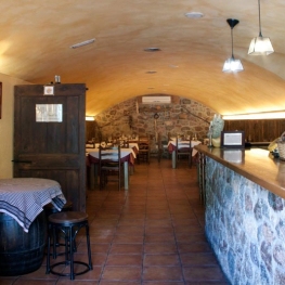
El Recó de l'Avi
Guardiola de Berguedà (a 7.6 Km)Typical homemade cuisine, with oak-grilled meats, a wide variety of tapas and…
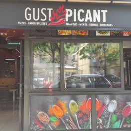
Restaurant Gust Picant
Berga (a 17.1 Km)At Gust Picant, you can enjoy affordable menus with a wide variety…
Bar Restaurant El Jardí
Sant Llorenç de Morunys (a 20.6 Km)The Bar-Restaurant El Jardí de Sant Llorenç de Morunys offers traditional cuisine…
Where to sleep
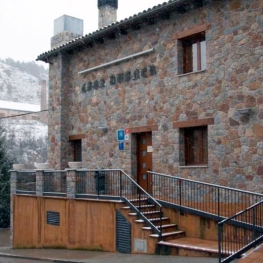
Hotel Casa Duaner
Guardiola de Berguedà (a 7.6 Km)The Casa Duaner Hotel in Guardiola de Berguedà offers modern facilities, a…
Cerdanya Viva Ecoestades
Prullans (a 14.7 Km)You imagine a place with paradisiacal views, to be able to choose…
Hostal Cal Franciscó
Gósol (a 10.4 Km)The hostel is located at a crossroads that leads to different routes,…
Hotel & Spa La Collada
Toses (a 11.4 Km)Hotel & Spa La Collada, a 4-star hotel with 90 rooms located…